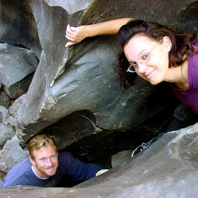
Fossil Falls on Hwy 395

While it may be a bit hot to visit here during summer, I thought I would let everyone know about this awesome "stretch break" along US Hwy 395, where the Mojave meets the Sierra Nevada. When you are on your way northbound toward Bishop, entering the lava corridor of the Eastern Sierra, look for a red cinder cone volcano on the right side of the highway. This easy to miss turn off is after Little Lake (which is the remains of a burnt hotel) & before Coso Junction. If you are driving over 55 mph, you may actually miss it.
To find Fossil Falls (which is not a waterfall anymore) -- turn right off Highway 395, on to a well marked gravel road called CINDER ROAD. High clearance vehicle is not required. Follow road to the right w/ signs approx. 1 mile & you will be at a small primitive BLM campground & trailhead parking lot. Surrounded by a field of black lava chunks, the Sierra Nevada mountains to the west and Death Valley Park to the east.
New picnic tables & pit toilets are provided. Stop, get outta the car, breathe, stretch & view the surreal terrain.

Standing inside ancient lava beds from the Owens River, you can breathe deep and take in the lunar-scape surroundings.
Hike from the parking lot less than half a mile & you are on top of a huge lava gorge, where a maze of fun awaits you. It's literally a jungle gym of climbing & exploring here.
Rock climbers love this spot and if you are careful you can manage to squeeze your fat ass into one of these lava tubes, cubby holes or narrow slots. Some of this terrain is smooth and slick, so it is easy to slip. Wear hiking shoes if you plan to explore deeper into the canyon. Your first time here you could easily get lost in the network of glossy black cliff features, spending an hour or more discovering new stuff - right off the highway!
Fossil Falls Campground
BLM Camp Sites in the main parking lot are RV and handicapped accessible. Dry camping, no hookups. Possibly a few more camp sites located behind the rocks, away from the main parking lot. Bureau of Land management is now charging an overnight fee for this camp.
Lttlbddy Steve said there were very interesting and odd looking insects that come out at night, so make sure to keep that tent zipped up tight and don't leave sleeping gear on the ground. Unless you like scorpions in your bedding!

Maps for the North Mojave Desert -
Forest Maps and Trail Topo Maps for Lower Eastern Sierra -
- Inyo National Forest Map
- Inyo Forest Topo Atlas
- South Sierra Map
- Golden Trout Trail Map
- Mount Whitney High Country Map
- Mount Whitney Zone Map
 |
| Lone Pine, CA |
Towns in the North Mojave & Owens Valley region:


