Posts

Showing posts with the label California

Usal Beach Campground
Image
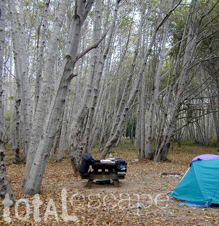
Lost Coast Camping, NorCal The USA Lumber Company ran a big wood mill on this part of the redwood coast back in the early days. This camp's name gets shortened to USAL. Usal Beach Campground near Shelter Cove, California This idyllic prime yet primitive, hard-to-reach beach campground is tucked well away from the crowds along the Pacific Coastal Hwy 1.  The region is California BLM land King Range National Conservation Area, or better known as the Lost Coast of California ... a famous stretch of wilderness coastline in between Mendocino and the Humboldt Redwoods. Dense forests and steep terrain located on the county line of Mendocino & Humboldt. Sinkyone Wilderness State Park is nearby. Usal Camp is the only place for drive-up car camping on the beach front in Northern Cal. All other developed camps in the area are located further inland (with forested surroundings), or backpacking, hike-in primitive campsites. Usal Campground on Usal Creek , has several idyllic se...

New Eastern Sierra Map

Image
Eastern Sierra Camping - Bridgeport, CA NEW EDITION ffor 2014 -  Humboldt Toiyabe National Forest USDA recently updated most of their National Forests maps to a new plastic waterproof versions, with El Dorado being the very last of the paper maps. Front cover design takes a twist with the new retro-looking map featured here - Toiyabe's Bridgeport Ranger District . It was updated and printed in 2014   This USDA Eastern Sierra map covers places like: Mono Lake   Lee Vining   Conway Summit Bridgeport   Buckeye Hot Springs Travertine Hot Springs East Walker River Lundy Lake   Twin Lakes   Virginia Lakes  Bodie Ghost Town   Green Creek   Upper Summers Meadow Dunderberg Meadow Hoover Wilderness This rural Eastern California National Forest region is located on US Highway 395 (north of Mammoth and south of Lake Tahoe). Autumn and aspen colors are quite impressive in this area, so make plans to visit in late Se...

Whiskeytown Lake NRA

Image
One great thing about Redding California is its proximity to awesome Northern California forests. Another is the big Sacramento River flowing right through the middle of town.   UPDATE: 2022 Updating this original 2007 blog post because of all the recent wildfires that have drastically affected the North State. Shasta Lake is due north & beyond that lies gigantic Mount Shasta. The Delta Fire & Hirz Fire have both burnt acres of terrain along Interstate 5 and many region may still be closed to camping and hiking. The PCT (Pacific Crest Trail) crosses this forest, north of the Shasta Lake/Reservoir. To the east is Lassen Volcanic National Park and half the park was burnt by the massive Dixie Fire. Both communities of Mineral and Mill Creek were spared and the forest is still intact. 2021 DIXIE FIRE - https://totalescape.blogspot.com/2021/12/dixie-fire-2021.html The first place you will see along Highway 299 after historic old town Shasta is Whiskeytown.  The whol...

California Wildfire Affected Areas: Donnell Fire

Image
Donnell Fire 2018 36,450 Acres Tuolumne County, California Dardanelle, CA Sonora Pass CA SR 108 (Hwy 108) Stanislaus River in 2004 Areas  affected by this wildfire: Stanislaus National Forest Carson Iceberg Wilderness  Donnell Lake Spicer Meadows Reservoir Stanuslaus River Arnot Creek  Douglas Creek Eagle Creek Dardanelle Resort  (slowly rebuilding) Barker Station Clark Fork Double Dome Rock County Line Trailhead Wheats Meadow Trailhead Trailheads  affected by this wildfire: Arnot Creek Trailhead Clark Fork Trailhead Columns of the Giants County Line Trailhead Disaster Creek Trailhead Seven Pines Trailhead Wheats Meadow Trailhead Meadow at end of Road # 6N06 Trails  affected by this wildfire: 19E06 Trail 19E16 Trail 19E47 Trail 19EV1208 Trail 19EV97 Trail 20E05 Trail 20E07 Trail 20E08 Trail 20E62 Trail NFS Dardanelle Campground in 2004 Campgrounds affected by this wildfire: Boulder Flat Campground Brightman Flat Campground Camp Jack Hazard Campground ...

California Wildfire Affected Areas: Carr Fire

Image
2018 Carr Fire Whiskeytown 229,651 Acres burned 1604 buildings destroyed 8 deaths Shasta County Trinity County Centerville, CA French Gulch, CA Igo, CA Keswick, CA Kett, CA Lewiston, CA Matheson, CA Old Shasta, CA West Redding, CA CA SR 299 - Hwy 299 (Eureka Way) French Gulch County Park Keswick Reservoir Rainbow Lake Shasta State Historic Park Spring Creek Reservoir Whiskeytown National Recreation Area Whiskeytown Lake Boulder Creek Brandy Creek Cannonball Creek Clear Creek Cottonwood Creek Crystal Creek Dodge Creek Indian Creek Mill Creek Papoose Creek Spring Creek Squaw Creek Whiskey Creek Whiskeytown NRA in 2002 Areas affected by thus wildfire: Barleyfield Peak Blue Mountain Buckhorn Bally Buckhorn Summit Bully Choop  Carr Powerhouse Chappie OHV Deadwood Highland Ridge Hoadley Peaks Iron Mountain Joes Peak Kanaka Peak Mad Mule Mountain Merry Mountain Mikes Peak Monarch Mountain Oak Bottom Marina Paradise Peak Shasta Bally Shirttail Peak Shoemaker Bally ...

California Wildfire Affected Areas: Mendocino Complex

Image
2018 Mendocino Complex Fire Ranch Fire + River Fire = Mendo Complex 459,123 Acres burned 280 structures destroyed 1 death Mendocino County Lake County Glenn County Colusa County Communities evacuated for this fire:  Lakeport, Kelseyville , Lucerne , Upper Lake, Nice , Saratoga Springs, Witter Springs, Potter Valley, Finley, parts of Hopland , and the tribal communities of Hopland Rancheria and Big Valley Rancheria.  Camped in Mendocino Forest for the first time in spring 2018;  Wildfire may have wiped out this lush forested area a few months later. Areas affected by this wildfire: CA SR 20 (Highway 20) Mendocino National Forest  Snow Mountain Wilderness Indian Valley Reservoir Black Butte River Eel River Anderson Creek Clover Creek Cold Creek Corbin Creek Stony Creek Anderson Ridge Bartlette Springs Barkerville Blue Slides Ridge Elk Mountain Gibson Ridge Goat Mountain Hull Mountain Letts Lake Pacific Ridge Scotts Creek Road South Cow Mountain...

California Wildfire Affected Areas: Walker Fire

Image
2019 Walker Fire Plumas County 54,608 Acres burned Antelope Lake, California Genesee Valley  East Plumas National Forest Antelope Lake Road Beckwourth - Genesee Road 70 Beckwourth - Genesee Road 111 Genesee Valley Road, east of Taylosville, CA Indian Creek Road 43 Babcock Meadow Babcock Peak Clarks Creek Elephants Playground Flournoy Bridge Franks Valley Frazier Cabin Indian Creek Last Chance Creek Murdock Crossing Notson Bridge Squaw Queen Creek Campgrounds affected by this fire:  [all located at Antelope Lake] Boulder Creek Campground Lone Rock Campground Long Point Campground Forest Roads affected by this fire:  Antelope Lake Road Beckwourth - Genesee Road 70 Beckwourth - Genesee Road 111 Genesee Valley Road Forest Rte #26N07 Forest Rte #26N13 Forest Rte #26N45 Forest Rte #26N54 Forest Rte #27N02Y Forest Rte #27N03 Forest Rte #27N07 Forest Rte #27N09 Forest Rte #27N10 Franks Valley Forest Rte #27N16Y (4WD) Forest Rte #27N41 Frasier Cabin Forest Rte #27N48 F...

California Wildfire Affected Areas: SQF Complex

Image
Castle Fire 2020 Sequoia Complex SQF Castle Fire + Shotgun Fire Tulare County 174,178 Acres burned 228 structures destroyed Lightning strike fires on the west slopes of the Sierra Nevada, along Western Divide Highway and Giant Sequoia National Monument. The lightning-caused Castle and Shotgun Fires were discovered on August 19, 2020, and later managed as one incident named the SQF Complex.  The Castle Fire burned on portions of the Sequoia National Forest and Giant Sequoia National Monument (131,087acres), Inyo National Forest (12,508 acres), Sequoia National Park (18,984 acres) Castle fire swept through portions of 20 different Sequoia groves in the southern Sierra. The number of mature Sequoia Trees that died could easily top 1000. Camp Nelson, CA Pierpoint Springs Ponderosa, CA Sequoia Crest Three Rivers, CA Wishon Campground in 2000 South Sequoia National Park   Giant Sequoia National Monument Western Divide Highway 190 Golden Trout Wilderness Sequoia National Forest Inyo ...