Posts

Showing posts from 2022

Usal Beach Campground
Image
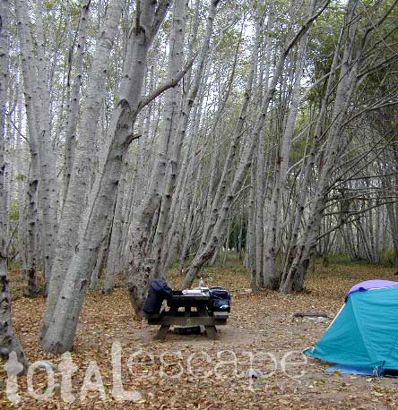
Lost Coast Camping, NorCal The USA Lumber Company ran a big wood mill on this part of the redwood coast back in the early days. This camp's name gets shortened to USAL. Usal Beach Campground near Shelter Cove, California This idyllic prime yet primitive, hard-to-reach beach campground is tucked well away from the crowds along the Pacific Coastal Hwy 1.  The region is California BLM land King Range National Conservation Area, or better known as the Lost Coast of California ... a famous stretch of wilderness coastline in between Mendocino and the Humboldt Redwoods. Dense forests and steep terrain located on the county line of Mendocino & Humboldt. Sinkyone Wilderness State Park is nearby. Usal Camp is the only place for drive-up car camping on the beach front in Northern Cal. All other developed camps in the area are located further inland (with forested surroundings), or backpacking, hike-in primitive campsites. Usal Campground on Usal Creek , has several idyllic se

New Eastern Sierra Map

Image
Eastern Sierra Camping - Bridgeport, CA NEW EDITION ffor 2014 -  Humboldt Toiyabe National Forest USDA recently updated most of their National Forests maps to a new plastic waterproof versions, with El Dorado being the very last of the paper maps. Front cover design takes a twist with the new retro-looking map featured here - Toiyabe's Bridgeport Ranger District . It was updated and printed in 2014   This USDA Eastern Sierra map covers places like: Mono Lake   Lee Vining   Conway Summit Bridgeport   Buckeye Hot Springs Travertine Hot Springs East Walker River Lundy Lake   Twin Lakes   Virginia Lakes  Bodie Ghost Town   Green Creek   Upper Summers Meadow Dunderberg Meadow Hoover Wilderness This rural Eastern California National Forest region is located on US Highway 395 (north of Mammoth and south of Lake Tahoe). Autumn and aspen colors are quite impressive in this area, so make plans to visit in late September or October if you like to fish. Wildflowers happen h

California Wildfire Affected Areas: Ferguson Fire

Image
Ferguson Fire 2018 96,901 Acres burned 10 buildings destroyed 2 firefighter deaths Bryan Hughes Braden Varney El Portal, CA Foresta, CA Wawona, CA Yosemite West, CA Sierra National Forest Stanislaus National Forest Yosemite National Park Highway 120 Highway 140 Highway 41   Merced River     Areas affected by the wildfire: El Portal Foresta Yosemite West Eagle Peak Cedar Lodge Bull Creek Rd #2S05  Big Grizzly Mountain Forest Road #20 Forest Route #1S13 Harden Pass Rd Pilot Peak Crocker Ridge (lower) Glacier Point Road Hite's Cove Indian Flat Jerseydale  Jerseydale Campground Clarks Valley Scott Road Nutmeg Gulch Devils Gulch Sweetwater Ridge Sweetwater Creek Ferguson Ridge Wawona Road Wawona Campground El Portal Trailer Court Miller Gulch Ned Gulch Montgomery Gulch Brown Peak Pinoche Peak Kirby Peak Footman Ridge Cathewood Saddle Chinquapin Eagle Peak Buena Vista Chowchilla Mountain Iron Creek Trailhead     Areas that were under evacuation orders:     Anderson Valley     Foresta  

Whiskeytown Lake NRA

Image
One great thing about Redding California is its proximity to awesome Northern California forests. Another is the big Sacramento River flowing right through the middle of town.   UPDATE: 2022 Updating this original 2007 blog post because of all the recent wildfires that have drastically affected the North State. Shasta Lake is due north & beyond that lies gigantic Mount Shasta. The Delta Fire & Hirz Fire have both burnt acres of terrain along Interstate 5 and many region may still be closed to camping and hiking. The PCT (Pacific Crest Trail) crosses this forest, north of the Shasta Lake/Reservoir. To the east is Lassen Volcanic National Park and half the park was burnt by the massive Dixie Fire. Both communities of Mineral and Mill Creek were spared and the forest is still intact. 2021 DIXIE FIRE - https://totalescape.blogspot.com/2021/12/dixie-fire-2021.html The first place you will see along Highway 299 after historic old town Shasta is Whiskeytown.  The whole Whiskey

California Wildfire Affected Areas: Monument Fire

Image
2021 Monument Fire Panther Fire Trinity County, California 223,124 Acres burned 52 structures destroyed Lightning strike fire that lasted 3 months, until full containment  Communities & Towns near this wildfire: Big Bar, CA Big Flat Burnt Ranch, CA Cedar Flat Coffee Creek Del Loma Hawkins Bar Hayfork, CA Helena, CA Hyampom, CA Junction City, CA Trinity Center, CA Trinity Pines Trinity Village Willow Creek, CA Highway 299 West Shasta Trinity National Forest Trinity Alps Wilderness New River Trinity River Bell Creek Bear Creek Bidden Creek Big Bar Creek Buckhorn Creek Canadian Creek Cedar Flat Creek Conner Creek Don Juan Creek Donaldson Creek Dutch Creek Dyer Creek Eagle Creek Farmer Ridge French Creek Hayfork Creek Hayshed Creek Italian Creek Jud Creek Love Letter Springs Maple Creek Mill Creek Miller Creek Miners Creek Packers Creek Panther Creek Price Creek Rowdy Bar Creek Rusch Creek Sailor Bar Creek Sandy Bar Creek Smoky Camp Creek Stetson Creek Swede Creek Tule Creek Whites Bar

California Wildfire Affected Areas: Whaleback Fire

Image
Whaleback Fire 2018 18,703 Acres burned Lassen County, California Eagle Lake (westside) Spaulding, CA Along the road to Spaulding Eagle Lake Road 201 (also known as Road A1) Lake View Drive (to Spaulding) Lassen National Forest Rain showers at Eagle Lake in 2011 Whaleback Mountain Brockman Flat Lava Beds Lava & Western shore of Eagle Lake, CA Campgrounds affected by this wildfire: Pine Ridge Campground Prison Spring Campground Forest Routes affected by this wildfire: Forest Rte #32N02 Eagle Lake Road 201 (Road A1) Road A1 (aka 201) Eagle Lake Rd https://en.wikipedia.org/wiki/Whaleback_Fire

California Wildfire Affected Areas: Donnell Fire

Image
Donnell Fire 2018 36,450 Acres Tuolumne County, California Dardanelle, CA Sonora Pass CA SR 108 (Hwy 108) Stanislaus River in 2004 Areas  affected by this wildfire: Stanislaus National Forest Carson Iceberg Wilderness  Donnell Lake Spicer Meadows Reservoir Stanuslaus River Arnot Creek  Douglas Creek Eagle Creek Dardanelle Resort  (slowly rebuilding) Barker Station Clark Fork Double Dome Rock County Line Trailhead Wheats Meadow Trailhead Trailheads  affected by this wildfire: Arnot Creek Trailhead Clark Fork Trailhead Columns of the Giants County Line Trailhead Disaster Creek Trailhead Seven Pines Trailhead Wheats Meadow Trailhead Meadow at end of Road # 6N06 Trails  affected by this wildfire: 19E06 Trail 19E16 Trail 19E47 Trail 19EV1208 Trail 19EV97 Trail 20E05 Trail 20E07 Trail 20E08 Trail 20E62 Trail NFS Dardanelle Campground in 2004 Campgrounds affected by this wildfire: Boulder Flat Campground Brightman Flat Campground Camp Jack Hazard Campground Clark Fork Campground Dardanelle C