Posts

California Wildfire Affected Areas: Mendocino Complex

Image
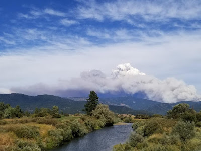
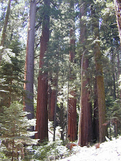
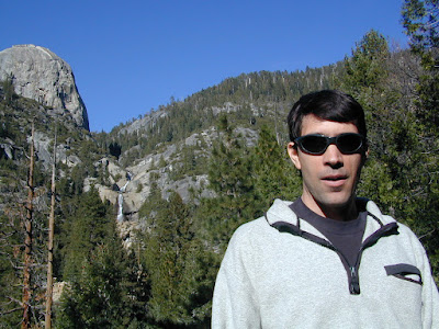
2018 Mendocino Complex Fire Ranch Fire + River Fire = Mendo Complex 459,123 Acres burned 280 structures destroyed 1 death Mendocino County Lake County Glenn County Colusa County Communities evacuated for this fire:  Lakeport, Kelseyville , Lucerne , Upper Lake, Nice , Saratoga Springs, Witter Springs, Potter Valley, Finley, parts of Hopland , and the tribal communities of Hopland Rancheria and Big Valley Rancheria.  Camped in Mendocino Forest for the first time in spring 2018;  Wildfire may have wiped out this lush forested area a few months later. Areas affected by this wildfire: CA SR 20 (Highway 20) Mendocino National Forest  Snow Mountain Wilderness Indian Valley Reservoir Black Butte River Eel River Anderson Creek Clover Creek Cold Creek Corbin Creek Stony Creek Anderson Ridge Bartlette Springs Barkerville Blue Slides Ridge Elk Mountain Gibson Ridge Goat Mountain Hull Mountain Letts Lake Pacific Ridge Scotts Creek Road South Cow Mountain BLM Wolf Creek Ridge Campgrounds affected b

California Wildfire Affected Areas: Walker Fire

Image
2019 Walker Fire Plumas County 54,608 Acres burned Antelope Lake, California Genesee Valley  East Plumas National Forest Antelope Lake Road Beckwourth - Genesee Road 70 Beckwourth - Genesee Road 111 Genesee Valley Road, east of Taylosville, CA Indian Creek Road 43 Babcock Meadow Babcock Peak Clarks Creek Elephants Playground Flournoy Bridge Franks Valley Frazier Cabin Indian Creek Last Chance Creek Murdock Crossing Notson Bridge Squaw Queen Creek Campgrounds affected by this fire:  [all located at Antelope Lake] Boulder Creek Campground Lone Rock Campground Long Point Campground Forest Roads affected by this fire:  Antelope Lake Road Beckwourth - Genesee Road 70 Beckwourth - Genesee Road 111 Genesee Valley Road Forest Rte #26N07 Forest Rte #26N13 Forest Rte #26N45 Forest Rte #26N54 Forest Rte #27N02Y Forest Rte #27N03 Forest Rte #27N07 Forest Rte #27N09 Forest Rte #27N10 Franks Valley Forest Rte #27N16Y (4WD) Forest Rte #27N41 Frasier Cabin Forest Rte #27N48 Forest Rte #27N51 Forest

California Wildfire Affected Areas: SQF Complex

Image
Castle Fire 2020 Sequoia Complex SQF Castle Fire + Shotgun Fire Tulare County 174,178 Acres burned 228 structures destroyed Lightning strike fires on the west slopes of the Sierra Nevada, along Western Divide Highway and Giant Sequoia National Monument. The lightning-caused Castle and Shotgun Fires were discovered on August 19, 2020, and later managed as one incident named the SQF Complex.  The Castle Fire burned on portions of the Sequoia National Forest and Giant Sequoia National Monument (131,087acres), Inyo National Forest (12,508 acres), Sequoia National Park (18,984 acres) Castle fire swept through portions of 20 different Sequoia groves in the southern Sierra. The number of mature Sequoia Trees that died could easily top 1000. Camp Nelson, CA Pierpoint Springs Ponderosa, CA Sequoia Crest Three Rivers, CA Wishon Campground in 2000 South Sequoia National Park   Giant Sequoia National Monument Western Divide Highway 190 Golden Trout Wilderness Sequoia National Forest Inyo National

California Wildfire Affected Areas: North Complex Fire

Image
Bear Fire + Claremont Fire 2020 North Complex Fire Butte County & Plumas County 318,935 Acres burned Curtain Falls on Middle Feather River The Bear Fire and the Claremont Fire were lightning strike forest fires that began in mid August - located in the remote, steep drainage of the Middle Feather River, between Lake Oroville and Quincy, CA.  The two small fires were under managed in a granite canyon for 3 weeks, while numerous other lightning 'complex' fires raged throughout California. USFS Plumas fire managers decided it was best to merge these two fires - right before a big wind event. And then, all hell broke loose. On Tuesday Sept 8, the northeasterly winds (blowing 60+ mph) pushed the combination fire westward, down canyon and like a funnel, it began spilling over into neighboring hills, forests and residential areas near Lake Oroville. Ancient forests, sacred sites, residential homes and historic cabins were torched in a matter of hours. Total Escape founder, DanaMi

California Wildfire Affected Areas: Creek Fire

Image
2020 Creek Fire Fresno County & Madera County 379,895 Acres burned 856 buildings destroyed Ron @ Big Creek Falls 2003 News Headlines: California National Guard rescued 242 people by helicopter from the Mammoth Pool Boat Launch throughout the night, due to a fast moving wildfire.   Central Sierra Nevada Mountains Big Creek Powerhouse Shaver Lake, CA Huntington Lake, CA Lakeshore, CA North Fork, CA Tollhouse, CA Mammoth Pool - summer 2008 Sierra Areas affected by the wildfire: California SR 168 (Highway 168) Huntington Lake Road Alder Springs Rd Dawn Road Musik Peak Rd Million Dollar Road County Road 233 County Road 2710 Minerets Road Sierra Vista Scenic Byway Sierra National Forest Ansel Adams Wilderness Kaiser Wilderness  Kaiser Pass Road Balsam Creek Balsam Forebay Balsam Meadow Balsam Meadows Sno-Park Bear Meadow Brown Cone Burrough Valley Cascadel Woods Cassidy Meadows Cedar Crest China Peak Ski Resort Chiquito Creek Chiquito Ridge Coyote Sno-Park Devils Table Edison Lake E

California Wildfire Affected Areas: Walkers Fire

Image
2021 Walkers Fire Tulare County 8,777 Acres Golden Trout Wilderness  Great Western Divide Little Kern River Sequoia National Forest Areas Affected by Wildfire: Newlywed Quinn Peak Shotgun Creek Soda Butte Soda Spring Creek South Fork Meadows Trail Tamarack Creek Hiking Trails # Affected 31E12 31E13 31E23 32E02 Walkers Fire Map JPG NOTE: There was another Walker wildfire in California called the Walker Fire 2019

California Wildfire Affected Areas: KNP Complex

Image
Colony Fire + Paradise Fire 2021 KNP Complex Tulare County 88,307 Acres Giant Forest, California Portions of Sequoia National Park have reopened but the south entrance is closed. Call ahead to find out current conditions and snow levels. DEATH RATE of Sequoias Between 10 to 14 percent of the entire Sierra Nevada population of giant sequoia trees over 4 feet in diameter were killed in the Castle Fire of 2020. Early estimates expect that on two fires in 2021, the KNP Complex and the Windy Fire, between 2,261 to 3,637 sequoias have already been killed or will die within a few years. wildfiretoday.com/tag/knp-complex/ Parks & Forests Affected by this Wildfire: Kings Canyon National Park  Sequoia National Park Generals Highway 198 Mineral King Road Buckeye Flat Campground  NPS Dorst Creek Campground NPS Potwisha Campground NPS Generals Highway Sequoia NP Areas Affected by Wildfire: Ash Mountain Big Baldy Ridge Big Tree Trail Buena Vista Creek Burnt Point Creek Cactus Point Castle Rocks