Posts

Showing posts with the label Sierra Nevada

New Eastern Sierra Map

Image
Eastern Sierra Camping - Bridgeport, CA NEW EDITION ffor 2014 -  Humboldt Toiyabe National Forest USDA recently updated most of their National Forests maps to a new plastic waterproof versions, with El Dorado being the very last of the paper maps. Front cover design takes a twist with the new retro-looking map featured here - Toiyabe's Bridgeport Ranger District . It was updated and printed in 2014   This USDA Eastern Sierra map covers places like: Mono Lake   Lee Vining   Conway Summit Bridgeport   Buckeye Hot Springs Travertine Hot Springs East Walker River Lundy Lake   Twin Lakes   Virginia Lakes  Bodie Ghost Town   Green Creek   Upper Summers Meadow Dunderberg Meadow Hoover Wilderness This rural Eastern California National Forest region is located on US Highway 395 (north of Mammoth and south of Lake Tahoe). Autumn and aspen colors are quite impressive in this area, so make plans to visit in late Se...

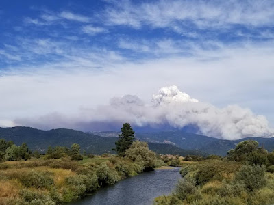
California Wildfire Affected Areas: Walker Fire

Image
2019 Walker Fire Plumas County 54,608 Acres burned Antelope Lake, California Genesee Valley  East Plumas National Forest Antelope Lake Road Beckwourth - Genesee Road 70 Beckwourth - Genesee Road 111 Genesee Valley Road, east of Taylosville, CA Indian Creek Road 43 Babcock Meadow Babcock Peak Clarks Creek Elephants Playground Flournoy Bridge Franks Valley Frazier Cabin Indian Creek Last Chance Creek Murdock Crossing Notson Bridge Squaw Queen Creek Campgrounds affected by this fire:  [all located at Antelope Lake] Boulder Creek Campground Lone Rock Campground Long Point Campground Forest Roads affected by this fire:  Antelope Lake Road Beckwourth - Genesee Road 70 Beckwourth - Genesee Road 111 Genesee Valley Road Forest Rte #26N07 Forest Rte #26N13 Forest Rte #26N45 Forest Rte #26N54 Forest Rte #27N02Y Forest Rte #27N03 Forest Rte #27N07 Forest Rte #27N09 Forest Rte #27N10 Franks Valley Forest Rte #27N16Y (4WD) Forest Rte #27N41 Frasier Cabin Forest Rte #27N48 F...

California Wildfire Affected Areas: SQF Complex

Image
Castle Fire 2020 Sequoia Complex SQF Castle Fire + Shotgun Fire Tulare County 174,178 Acres burned 228 structures destroyed Lightning strike fires on the west slopes of the Sierra Nevada, along Western Divide Highway and Giant Sequoia National Monument. The lightning-caused Castle and Shotgun Fires were discovered on August 19, 2020, and later managed as one incident named the SQF Complex.  The Castle Fire burned on portions of the Sequoia National Forest and Giant Sequoia National Monument (131,087acres), Inyo National Forest (12,508 acres), Sequoia National Park (18,984 acres) Castle fire swept through portions of 20 different Sequoia groves in the southern Sierra. The number of mature Sequoia Trees that died could easily top 1000. Camp Nelson, CA Pierpoint Springs Ponderosa, CA Sequoia Crest Three Rivers, CA Wishon Campground in 2000 South Sequoia National Park   Giant Sequoia National Monument Western Divide Highway 190 Golden Trout Wilderness Sequoia National Forest Inyo ...

California Wildfire Affected Areas: Creek Fire

Image
2020 Creek Fire Fresno County & Madera County 379,895 Acres burned 856 buildings destroyed Ron @ Big Creek Falls 2003 News Headlines: California National Guard rescued 242 people by helicopter from the Mammoth Pool Boat Launch throughout the night, due to a fast moving wildfire.   Central Sierra Nevada Mountains Big Creek Powerhouse Shaver Lake, CA Huntington Lake, CA Lakeshore, CA North Fork, CA Tollhouse, CA Mammoth Pool - summer 2008 Sierra Areas affected by the wildfire: California SR 168 (Highway 168) Huntington Lake Road Alder Springs Rd Dawn Road Musik Peak Rd Million Dollar Road County Road 233 County Road 2710 Minerets Road Sierra Vista Scenic Byway Sierra National Forest Ansel Adams Wilderness Kaiser Wilderness  Kaiser Pass Road Balsam Creek Balsam Forebay Balsam Meadow Balsam Meadows Sno-Park Bear Meadow Brown Cone Burrough Valley Cascadel Woods Cassidy Meadows Cedar Crest China Peak Ski Resort Chiquito Creek Chiquito Ridge Coy...

California Wildfire Affected Areas: Caldor Fire

Image
2021 Caldor Fire 221,835 Acres  El Dorado County, California Caldor, CA Grizzly Flats, CA Kirkwood, CA Kyburz, CA Meyers, CA Strawberry, CA Twin Bridges, CA Silver Lake from CA State Route 88 California SR 88 (Hwy 88 Carson Pass) US Highway 50 (Hwy 50) Eldorado National Forest Desolation Wilderness American River , Silver Fork Consumnes River, Steely Fork Consumnes River, Middle Fork Consumnes River, North Fork Wildfire Affected Areas:  Caples Lake Jenkinson Lake Kirkwood Lake Shealor Lakes Silver Lake @ Carson Twin Lakes Woods Lake Wrights Lake Kirkwood Lake Heavenly Valley Ski Resort Iron Mountain Snow Park Kirkwood Ski Resort Sierra Tahoe Ski Resort Caples Lake Campground China Flat Campground Lovers Leap Campground Kirkwood Campground Martin Meadow Campground Middle Fork Consumnes Campground PiPi Campground Sand Flat Campground Silver Fork Campground Silver Lake Campground East Silver Lake Campground West Woods Lake Campground Wrights Lake Campground Kirkwood Campgr...

California Wildfire Affected Areas: Tamarack Fire

Image
2021 Tamarack Fire 68,637 Acres burned Alpine County, California Markleeville, CA Woodfords, CA Hollbrook Highlands, NV Spring Valley, NV US Highway 395 (Hwy 395) California SR 88 (Hwy 88) California SR 89 (Hwy 89)   Meadows near Grover Hot Springs Toiyabe National Forest Turtle Rock County Park Grover Hot Springs State Park   Carson River East Fork Indian Creek Reservoir  Harvey Place Reservoir   Indian Creek Reservoir Wildfire Affected Areas:  Airport Road Barney Riley Bryant Creek Buck Creek Charity Valley Creek Haypress Flat Hot Springs Creek Indian Creek Leviathan Mine Road Little Cottonwood Canyon Millberry Canyon & Creek Mountaineer Creek Musser & Jarvis Creek Pleasant Valley Pleasant Valley Creek Poor Boy Creek Raymond Canyon Creek Sawmill Creek Sawmill Road Scossa Canyon Road Shay Creek Spratt Creek Thornburg Canyon   Markleeville, California       https://en.wikipedia.org/wiki/Tamarack_Fire TAMARACK FIRE peri...

California Lakes With Water

Image
California Lake Destinations Record low lake levels at most reservoirs & lakes! The mega drought continues. Don't be disappointed on vacation: Lack of water at your lake destination may leave you mad this season. Know before you go. Check out the California Water Information page for more specific information. Reservoirs listed below are the lakes with the most water in California (as of June 2015). Number represents percent of capacity. WHISKEYTOWN LAKE West of Redding, CA 98% full  LEWISTON LAKE Trinity County, Weaverville, CA 94%  ANTELOPE LAKE Northern Sierra, Susanville, CA 99%  ENGLEBRIGHT LAKE Yuba Gold Co, Grass Valley, CA 95%  BULLARDS BAR Reservoir Gold Country, Grass Valley, CA 59%  ICE HOUSE Reservoir Gold Country, Placerville, CA 84%  UNION VALLEY Reservoir Gold Country, Placerville, CA 81%  LAKE TULLOCH Central Valley, Modesto, CA 96%  INDEPENDENCE LAKE High Sierra, Truckee, CA 95%  PYRAMID LAKE L...

Gold Country Map

Image
Destinations Map of Gold Country All old REGION maps on DESTINATIONS will slowly be replaced this summer with new, customized GoogleMaps. Showing links to small towns, sightseeing stops, hiking trailheads, dining options, cabins and camping. The destinations and links will grow over time with more being added. Sierra Nevada Foothills, Historical Gold Rush California

Sierra Mountains Map

Image
Destinations Map of The Sierras Long ago I began compiling photos and data on remote back roads of the Sierra Nevada mountains. Now it's my (dream) job. Reworking and updating old pages every decade, whether they need it or not. All old REGION maps on DESTINATIONS will slowly be replaced this summer with new, customized GoogleMaps. Showing links to small towns, sightseeing stops, hiking trailheads, dining options, cabins and camping. The highest peaks in the nation seem like a good place to start. Sierra Nevada Mountains, California

Romantic California

Image
Romance for Camping Couple Vacations in California Why not keep the passion alive all year long. Take solo weekends away from one another and also vacation as a couple. All local, outdoors and on a budget. Kick your creativity into high gear and plan something totally spontaneous: Get a cabin or condo on the slopes for a few days. Book a lake view suite at a small resort, read, relax and fish all day long. Walk in the forest, bring a picnic and lay out to stargaze at night. Travel locally to enhance your love life, snuggle up close to a cozy fireplace, with a good bottle of wine. Hike, bike and enjoy the outdoors. Holiday season road trips & Valentine weekend ideas Local small towns in California is what Total Escape is all about. We have only small, independent lodges , but focus more on bed & breakfast inns , camping sites and cabin rentals . Discover more, stay local, spend less and enjoy your honey pie more often. top romantic places in California Auburn A...