Posts

Showing posts with the label National Forest

Lily Pad Campground

Image
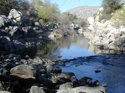
Lilypad Campground @ Lake Wishon Reservoir Sierra National Forest, California The long journey up the mountain into the Sierra National Forest is only for the true adventure seekers. First off, get a good forest map . Second, plan several days if not a full week off of work to explore this region in depth. It is a long drive from most anywhere in California, and this spot is way, way tucked back in there right up against the High Sierra peaks and wildness. East of in Fresno, historic village of Clovis is a good lunch stop in route. Drive up mountain on Hwy. 168, turn right at Shaver Lake on to Dinkey Creek Rd. Now you will clock the mileage 28.7 miles to the camp. Drive past McKinley Grove and past Dinkey Creek. Follow signs to Wishon Reservoir. This campground is located adjacent to the road before you reach the dam. All this travel time will have you asking 'is it worth it'? The answer is 'yes'..... if you want an uncrowded lake with plenty of wi

California Wildfires 2013

Image
Wildfires in western states are common place each summer with the typical "wildfire season" starting in mid summer and lasting into late Autumn, or until the first significant precipitation. The less rain in winter, the drier the land. The less snow in the mountains, the less water in the rivers, creeks and reservoirs. When significant drought conditions in California meet with dry springtime chaparral, wild land fires can easily be ignited.  Campfires restrictions are tighter than usual this summer 2013, so knnow the current conditions and restrictions by contacting the nearest ranger station. Remember that campfire safety is always key. NO CAMP FIRES, what?   What a way to start the summer! as of June 3, 2013 : The lower half of California is in extreme drought conditions and backcountry fire restrictions are already in place.  This means you can only legally have a campfire inside a developed campground. Severe conditions may escalate to 'no campfires anyw

Bass Lake Camping

Image
Bass Lake is a very popular outdoor recreation area in Gold Country California. Lake Camping, due mainly to the fact that it is next to Yosemite National Park 's south entrance, Hwy 41. Bass Lake has good fishing, boating, plenty campgrounds & this pine forested lake is close to the Central Valley, north of Fresno, CA. aka - Crane Valley Reservoir  Crane Valley Dam Bass Lake offers outdoor recreation: marinas, fishing, permits, public boat launches, boat rentals, kayak rentals, jet ski rentals, horseback rides, horseback and hiking trails. Residential cabins, homes and condo neighborhoods surround the lake on all sides. There are numerous Sequoia Groves tucked way back near Yosemite, behind Bass Lake in Sierra National Forest. Miles and miles of forest roads to explore will lead to secluded, primitive camp sites (free), small campgrounds, creek fishing, lake fishing and recreation, higher elevations, backpacker trailheads, hiking trails, kayaking creeks and rock cli

Kern River Camping

Image
Camping is great here nearly year round, but campfires restrictions are often tight in dry summer months and into late fall. The Kern River draws visitors from Southern California, as well as Central Cal. It is the southern most big river of the Sierra Nevada mountain range. Located near a few big Sequoia trees, the Kern River winds thru Golden Trout Wilderness & Sequoia National Forest, dumping into Lake Isabella before heading west to the flatlands of Bako. The smaller & lesser known south fork of the Kern River is located way up top at Monache; Granite peaks, joshua trees, sage meadows & wilderness near Olancha Peak, on the very border of the North Mojave desert. Plenty cool stuff to see and do around the Lower Kern Canyon: Alta Sierra Domelands Wilderness Fairview CA Golden Trout Wilderness Kennedy Meadows Kernville CA Lake Isabella Pondersosa Remington Hot Springs Road's End Sequoia National Forest Wofford Heights CA Upper Kern is often thought

Map Availability

Image
Maps can save your life. Maps can get you un-lost and can show you the way. Maps are your escape route outta the city. In a digital world where we are so connected w/ internet, smartphones and GoogleMaps, it is amazing that folks can find there way to real back roads of California. Don't be shocked when your digital signal drops at the wilderness edge and you are finally "away". Most online map sources are NOT accurate beyond the city limits, much less the forest boundary. Seriously folks, THEY don't want you out there. There is no place in the Wilderness to spend any money. Many have not properly logged the back roads yet, or perhaps they just won't make it available to the general public. You'll be lucky if they get the road number correct. BACK ORDERED / BACKORDER? OUT OF PRINT, OUT OF STOCK Availability of good maps is an ongoing issue. It's a unique factor in the map selling business. Although Total Escape carries a variety of Californ

Sequoia Forest Update

Image
Update for Sequoia Forest, 2012 Southern Sierra areas include - Sequoia National Forest, Kern River Canyon, Kernville, Tehachapi, Kennedy Meadows, Golden Trout, Domeland, Western Divide, Giant Sequoia National Monument. Further north, there is a small chunk of National Forest land smack dab in between Sequoia & Kings Canyon National Parks, some of the best, free Sequoia car camping anywhere . new: USDA National Forest waterproof map, updated and printed in late 2011 . The Wilderness areas of the Southern Sierra Nevada, known as SEQUOIA, has renamed their ranger districts too. Kern river & Sequoia ranger offices What was once Greenhorn Ranger District is now called Kern River Ranger District - one office in Kernville and one office on Lake Isabella .  Sequoia Hot Springs Ranger District in California Hot Springs is gone and a new Western Divide Ranger District is located in Springville, CA . Giant Sequoia is part of the Western Divide Highway, up near Ponder

tour california map

Image
You can pick up any popular road atlas of California in the supermarket. These Rand McNalley's and Thomas Brothers map books will show you how to get around in the freeways and the cities of Cali. We wanna show you more, much more. The real scenic drives, the back roads and rural highways. More of REAL CALIFORNIA Total Escape has every possible wilderness map you could ever need for this golden state. The Sierra mountains, the Coast, SoCal and NorCal. We want to inspire you to be outside, to hike and explore the back roads. To fish, kayak and snow ski. To re-create in our recreation paradise called Cali-forn-ia. MAP STORE - for planning your escape

Sequoia Map

Image
  If you are searching for maps on the mighty Sequoia region of California, we may be able to help here at Total Escape. First, decide what park or forest. There are up more than 6 'agencies' managing our Giant Sequoia Trees in the Sierra Nevada Mountains. See the list below w/ maps. Big, Old, Huge, Tall Trees : overview page for the Redwoods on the California North Coast, the Sequoia of the Sierra Nevada mountains and the oldest trees, the Ancient Bristlecone Pines over on the east side. Sierra Nevada SEQUOIA GROVES can be found in: Sequoia National Forest Sequoia National Park Kings Canyon National Park Yosemite National Park Mountain Home State Forest Calaveras Big Trees State Park Giant Sequoia National Monument SEQUOIA MAPS below: printed on polypropylene plastic, waterproof maps, tear-resistant, recyclable Sequoia National Forest Map USDA Sequoia National Park Map (NatGeo) Sequoia / Kings Canyon Map (Tom Harrison) Sierra National Forest M

fishaholics

Image
Many times over the years of Total Escape, I get letters such as this one below, which makes me realize just how important it is to take your kids out traveling & camping. My name is Wendy and when I was a toddler, we used to camp at Lundy Lake. It was pure wilderness then and my dad used to make whistles for us out of the birch trees I think. I just wanted to share my memories with someone that might love to hear what it was like then. I haven't been there since I was about 8 or 9, but we took our summer vacation every single year to the High Sierras & Virginia Lakes from years 1952-1971. What sweet memories! We went to Green Creek when no one hardly knew it was there. My dad and mom were fishaholics and we lived in Santa Barbara CA and we love the high Sierras.  how to find these sacred spaces - California Lakes & Reservoirs California National Forest Maps California Wilderness Maps California Cabin Rentals   California Rivers California Creek Camping C

Hillbilly Off-Roaders

This term above is actually a mental state, not a geographic location. Although you are more likely to find these guys on the back roads in rural regions. CB radios & all. Exactly one week ago, at sundown I was calmly working online & watering flowers. Then HE called. The sexy boy, who I cannot say no to. "Where's my car?" I asked. "It's fine, it's in my driveway at home". Your stuck, stranded, wheeling where? Off Miller, shit! After I pinpointed their location on my Los Padres topo atlas, I am now in the process of rescuing some local off-roader pals - in my AWD Saab? How many rednecks in town can you get to do this right now? (Can't you call some male friends to help?) Hint: These are not the same 4x4 dudes that showed for the Quatal Canyon CleanUp. NO, go pick up the Amigo in Frazier & here's the long list of supplies. Since I haven't been on a 4WD rescue in 3 years, I jump at the chance to see the Sespe at night in th