Posts

Whiskeytown Lake NRA

Image
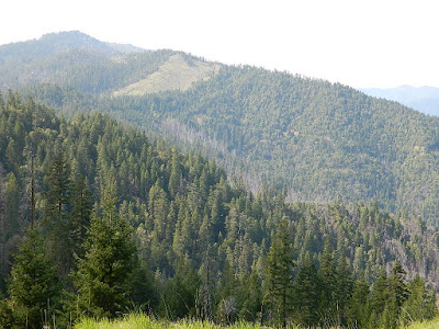
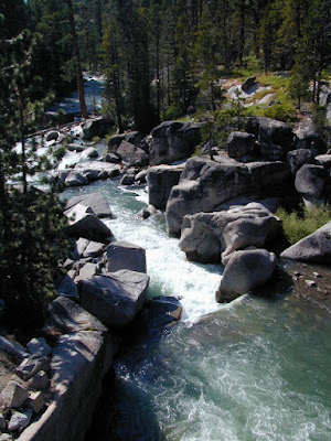
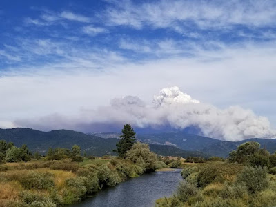
One great thing about Redding California is its proximity to awesome Northern California forests. Another is the big Sacramento River flowing right through the middle of town.   UPDATE: 2022 Updating this original 2007 blog post because of all the recent wildfires that have drastically affected the North State. Shasta Lake is due north & beyond that lies gigantic Mount Shasta. The Delta Fire & Hirz Fire have both burnt acres of terrain along Interstate 5 and many region may still be closed to camping and hiking. The PCT (Pacific Crest Trail) crosses this forest, north of the Shasta Lake/Reservoir. To the east is Lassen Volcanic National Park and half the park was burnt by the massive Dixie Fire. Both communities of Mineral and Mill Creek were spared and the forest is still intact. 2021 DIXIE FIRE - https://totalescape.blogspot.com/2021/12/dixie-fire-2021.html The first place you will see along Highway 299 after historic old town Shasta is Whiskeytown.  The whole Whiskey

California Wildfire Affected Areas: Monument Fire

Image
2021 Monument Fire Panther Fire Trinity County, California 223,124 Acres burned 52 structures destroyed Lightning strike fire that lasted 3 months, until full containment  Communities & Towns near this wildfire: Big Bar, CA Big Flat Burnt Ranch, CA Cedar Flat Coffee Creek Del Loma Hawkins Bar Hayfork, CA Helena, CA Hyampom, CA Junction City, CA Trinity Center, CA Trinity Pines Trinity Village Willow Creek, CA Highway 299 West Shasta Trinity National Forest Trinity Alps Wilderness New River Trinity River Bell Creek Bear Creek Bidden Creek Big Bar Creek Buckhorn Creek Canadian Creek Cedar Flat Creek Conner Creek Don Juan Creek Donaldson Creek Dutch Creek Dyer Creek Eagle Creek Farmer Ridge French Creek Hayfork Creek Hayshed Creek Italian Creek Jud Creek Love Letter Springs Maple Creek Mill Creek Miller Creek Miners Creek Packers Creek Panther Creek Price Creek Rowdy Bar Creek Rusch Creek Sailor Bar Creek Sandy Bar Creek Smoky Camp Creek Stetson Creek Swede Creek Tule Creek Whites Bar

California Wildfire Affected Areas: Whaleback Fire

Image
Whaleback Fire 2018 18,703 Acres burned Lassen County, California Eagle Lake (westside) Spaulding, CA Along the road to Spaulding Eagle Lake Road 201 (also known as Road A1) Lake View Drive (to Spaulding) Lassen National Forest Rain showers at Eagle Lake in 2011 Whaleback Mountain Brockman Flat Lava Beds Lava & Western shore of Eagle Lake, CA Campgrounds affected by this wildfire: Pine Ridge Campground Prison Spring Campground Forest Routes affected by this wildfire: Forest Rte #32N02 Eagle Lake Road 201 (Road A1) Road A1 (aka 201) Eagle Lake Rd https://en.wikipedia.org/wiki/Whaleback_Fire

California Wildfire Affected Areas: Donnell Fire

Image
Donnell Fire 2018 36,450 Acres Tuolumne County, California Dardanelle, CA Sonora Pass CA SR 108 (Hwy 108) Stanislaus River in 2004 Areas  affected by this wildfire: Stanislaus National Forest Carson Iceberg Wilderness  Donnell Lake Spicer Meadows Reservoir Stanuslaus River Arnot Creek  Douglas Creek Eagle Creek Dardanelle Resort  (slowly rebuilding) Barker Station Clark Fork Double Dome Rock County Line Trailhead Wheats Meadow Trailhead Trailheads  affected by this wildfire: Arnot Creek Trailhead Clark Fork Trailhead Columns of the Giants County Line Trailhead Disaster Creek Trailhead Seven Pines Trailhead Wheats Meadow Trailhead Meadow at end of Road # 6N06 Trails  affected by this wildfire: 19E06 Trail 19E16 Trail 19E47 Trail 19EV1208 Trail 19EV97 Trail 20E05 Trail 20E07 Trail 20E08 Trail 20E62 Trail NFS Dardanelle Campground in 2004 Campgrounds affected by this wildfire: Boulder Flat Campground Brightman Flat Campground Camp Jack Hazard Campground Clark Fork Campground Dardanelle C

California Wildfire Affected Areas: Carr Fire

Image
2018 Carr Fire Whiskeytown 229,651 Acres burned 1604 buildings destroyed 8 deaths Shasta County Trinity County Centerville, CA French Gulch, CA Igo, CA Keswick, CA Kett, CA Lewiston, CA Matheson, CA Old Shasta, CA West Redding, CA CA SR 299 - Hwy 299 (Eureka Way) French Gulch County Park Keswick Reservoir Rainbow Lake Shasta State Historic Park Spring Creek Reservoir Whiskeytown National Recreation Area Whiskeytown Lake Boulder Creek Brandy Creek Cannonball Creek Clear Creek Cottonwood Creek Crystal Creek Dodge Creek Indian Creek Mill Creek Papoose Creek Spring Creek Squaw Creek Whiskey Creek Whiskeytown NRA in 2002 Areas affected by thus wildfire: Barleyfield Peak Blue Mountain Buckhorn Bally Buckhorn Summit Bully Choop  Carr Powerhouse Chappie OHV Deadwood Highland Ridge Hoadley Peaks Iron Mountain Joes Peak Kanaka Peak Mad Mule Mountain Merry Mountain Mikes Peak Monarch Mountain Oak Bottom Marina Paradise Peak Shasta Bally Shirttail Peak Shoemaker Bally Shoemaker Gulch South Fork Mo

California Wildfire Affected Areas: Mendocino Complex

Image
2018 Mendocino Complex Fire Ranch Fire + River Fire = Mendo Complex 459,123 Acres burned 280 structures destroyed 1 death Mendocino County Lake County Glenn County Colusa County Communities evacuated for this fire:  Lakeport, Kelseyville , Lucerne , Upper Lake, Nice , Saratoga Springs, Witter Springs, Potter Valley, Finley, parts of Hopland , and the tribal communities of Hopland Rancheria and Big Valley Rancheria.  Camped in Mendocino Forest for the first time in spring 2018;  Wildfire may have wiped out this lush forested area a few months later. Areas affected by this wildfire: CA SR 20 (Highway 20) Mendocino National Forest  Snow Mountain Wilderness Indian Valley Reservoir Black Butte River Eel River Anderson Creek Clover Creek Cold Creek Corbin Creek Stony Creek Anderson Ridge Bartlette Springs Barkerville Blue Slides Ridge Elk Mountain Gibson Ridge Goat Mountain Hull Mountain Letts Lake Pacific Ridge Scotts Creek Road South Cow Mountain BLM Wolf Creek Ridge Campgrounds affected b

California Wildfire Affected Areas: Walker Fire

Image
2019 Walker Fire Plumas County 54,608 Acres burned Antelope Lake, California Genesee Valley  East Plumas National Forest Antelope Lake Road Beckwourth - Genesee Road 70 Beckwourth - Genesee Road 111 Genesee Valley Road, east of Taylosville, CA Indian Creek Road 43 Babcock Meadow Babcock Peak Clarks Creek Elephants Playground Flournoy Bridge Franks Valley Frazier Cabin Indian Creek Last Chance Creek Murdock Crossing Notson Bridge Squaw Queen Creek Campgrounds affected by this fire:  [all located at Antelope Lake] Boulder Creek Campground Lone Rock Campground Long Point Campground Forest Roads affected by this fire:  Antelope Lake Road Beckwourth - Genesee Road 70 Beckwourth - Genesee Road 111 Genesee Valley Road Forest Rte #26N07 Forest Rte #26N13 Forest Rte #26N45 Forest Rte #26N54 Forest Rte #27N02Y Forest Rte #27N03 Forest Rte #27N07 Forest Rte #27N09 Forest Rte #27N10 Franks Valley Forest Rte #27N16Y (4WD) Forest Rte #27N41 Frasier Cabin Forest Rte #27N48 Forest Rte #27N51 Forest