Posts

Showing posts with the label wilderness

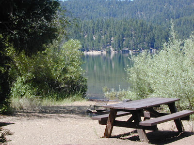
Mokelumne River Canyon

Image
Mokelumne Peak is at a towering 9334' elevation in the High Sierra known as Mokelumne Wilderness . Granite scenery, high country, big water at high elevations. 105,165 acres straddles the crest of the central Sierra Nevada, within the Stanislaus, Eldorado, and Toiyabe National Forests; bordered by Highway 4 on the south and Highway 88 on the north. The Mokelumne River starts way up near Blue Lakes (South of Tahoe) which flows down to Salt Springs Reservoir, on the Amador & Calaveras county line. Once inside the Gold Country region the Mokelumne River drains into Pardee Reservoir, near Jackson CA . Salt Springs Reservoir has a trailhead for the Mokelumne Wilderness. Ellis Road - El Dorado National Forest Road #8N25 a signed turn off of Sierra Highway 88; a steep long, winding, hairy drive on a paved, back road that switchbacks down to river and prime camping. Minimal access and recreation at Salt Springs reservoir. Mokelumne River Campground NFS Mokelu

Half Moon Campground

Image
Los Padres NF: Half Moon Camp 2006 Day Fire wildfire burned most of the Sespe Wilderness Piru Creek Camping Lockwood Valley, Sespe Wilderness Trailheads Late afternoon sun at uncrowded Half Moon campground   Los Padres National Forest West of Frazier Park & north of Ojai Camping - 12 camp sites on creek @ 4700' elevation vault toilet, creek, pine forest, Sespe Wilderness first come, first served camping Max Camper Length: 0 RV, motorhomes, camper trailers are not advised Access by long dirt road with creek crossings, high clearance recommended. Lockwood Ranger Station: 661-245-3731 Backpacking, car camping, fishing, hiking, horseback riding, hunting, mountain biking, off-roading. Piru Creek valley overlook on the way to Mutau Flat and Half Moon From Ojai, California take Hwy 33. Turn right (east) on Lockwood Valley. Turn right (south) on Mutau Flat Road #7N03 and continue 9 miles to the campground at junction with #7N13. From Frazier Park,

California Fire Map

Image
California Wildfires & Fire Information Extreme drought conditions means super high wildfire dangers for all of California. As of August 1st, nearly 60% of the golden state is under EXCEPTIONAL drought, one level up from the 'extreme' classification. We are more than one years worth of water overdue. Wildfires in California are quiet common and occur annually in the later part of the year (summer - autumn)  when the natural vegetation, brush and forests are the driest. Drought.gov will show just how bad the drought conditions are currently in the Western U.S. drought.gov Southern California as well as Northern California experience wildland fires, and since Central California is backed by the Sierra Nevadas, you should expect forest fires at high elevations and lower river canyons too. California is currently experiencing extreme fire dangers, so many parks and forest areas have higher than normal restrictions. The new normal is becoming extreme, as you can im

Where'd She Go?

Image
It often seems as if I have forgotten about this long standing blogger blog, leaving it for months at a time without a post (maybe while traveling for weeks or working other more pressing projects). Over this past winter, I spent much time rebuilding older pages to a new format (WordPress) Outside Blog and I will continue this throughout the year. Covering the back roads like no other! I, DanaMite , am dedicated to the whole of Total Escape, my 8000 page web site on California travel destinations, off the beaten path . Established way back in 1996, in the web 1.0 days, on a 33k modem. First and foremost that I can offer is real world content, real experiences, travel logs, photos, GPS data and research I gather while exploring the golden state. Sleeping on the ground, tent camping outside of developed campgrounds, way back there "out in the field". Lakes, Rivers, Wilderness, Outdoor Recreation, Small Towns & Unique Lodging Managing databases on California d

Campsites in Southern California

Image
Camping sites in Southern California While camping in California is an amazing experience overall with thousands of picture perfect settings to pitch your tent, camping in SoCal definitely has it's limitations. The primary reasons are.... Camping in SoCal is - 1. crowded (half the population is located in the lower third of the state) 2. dry terrain (minimal rivers, dry seasonal streams, few waterfalls) 3. wildfire prone (with average rainfall of only 10") 4. costly (all developed campgrounds charge fees) 5. not secluded (with suburbia spread into foothills, busy roads nearby) With the California population nearing 40 million, you will need to do your research in order to find a good, secluded, scenic camping area. Coastal camp sites are the most popular on the list and you should seek advanced reservation w/ the State Park system. City camping is mostly RV parks and a few county parks. Beyond the neighborhoods, countryside camping in the coastal footh

Trinity Alps Wilderness Topo Map

Image
Trinity Wilderness Map  new edition 2013  After 2 years outta stock status the Trinity Alps Wilderness Map is finally back in stock at Total Escape. USDA recently updated, reprinted and released this long-waited NorCal title and we expect it to be a great seller (just like the last version was). Backpacking, day hiking, horseback, high elevation camping - all campgrounds, roads, trails, waterfalls, lakes, mountain peaks and trailheads. Trinity River, Salmon River, Klamath River, Highway 96, Highway 3, Forks of the Salmon. Surrounded by Six Rivers National Forest and Trinity National Forest, both west of Interstate 5 in Northern California.   nearby towns include -  Douglas City, CA Etna, CA Fort Jones, CA French Gulch Gazelle, CA Happy Camp, CA Helena Junction City Lewiston, CA Orleans, CA Trinity Center Weaverville, CA Willow Creek Yreka, CA   Big Foot in Happy Camp, CA

Best Hidden Campsites

Image
Hidden Campsites small campgrounds, tent camping, free camping We know, we know, you want a lake to yourself and don't really wanna share a huge campground with hundreds of other folks. Picking a decent campground online is difficult enough - with the numerous managing agencies , confusing park names, long driving times, freeway routes and hefty reservation fees. Avoid reservations all together and discover travel off the beaten path. Mid week campground stays can be better than weekends, but during summertime all week long is peak season w/ maximum visitors circulating. Neighbors at camp can often mean annoyances - children, generator noise, vehicle engines, boating trailers, music and partying. Quiet time is usually 10pm to 7am, but that doesn't mean the loud garbage truck won't wake you at 6:50am. big campgrounds vs. small Big campgrounds are developed parks with more than 20 camp sites, usually found along paved roads and highways. Level tent spots, pa

Lily Pad Campground

Image
Lilypad Campground @ Lake Wishon Reservoir Sierra National Forest, California The long journey up the mountain into the Sierra National Forest is only for the true adventure seekers. First off, get a good forest map . Second, plan several days if not a full week off of work to explore this region in depth. It is a long drive from most anywhere in California, and this spot is way, way tucked back in there right up against the High Sierra peaks and wildness. East of in Fresno, historic village of Clovis is a good lunch stop in route. Drive up mountain on Hwy. 168, turn right at Shaver Lake on to Dinkey Creek Rd. Now you will clock the mileage 28.7 miles to the camp. Drive past McKinley Grove and past Dinkey Creek. Follow signs to Wishon Reservoir. This campground is located adjacent to the road before you reach the dam. All this travel time will have you asking 'is it worth it'? The answer is 'yes'..... if you want an uncrowded lake with plenty of wi

California Wildfires 2013

Image
Wildfires in western states are common place each summer with the typical "wildfire season" starting in mid summer and lasting into late Autumn, or until the first significant precipitation. The less rain in winter, the drier the land. The less snow in the mountains, the less water in the rivers, creeks and reservoirs. When significant drought conditions in California meet with dry springtime chaparral, wild land fires can easily be ignited.  Campfires restrictions are tighter than usual this summer 2013, so knnow the current conditions and restrictions by contacting the nearest ranger station. Remember that campfire safety is always key. NO CAMP FIRES, what?   What a way to start the summer! as of June 3, 2013 : The lower half of California is in extreme drought conditions and backcountry fire restrictions are already in place.  This means you can only legally have a campfire inside a developed campground. Severe conditions may escalate to 'no campfires anyw

Bass Lake Camping

Image
Bass Lake is a very popular outdoor recreation area in Gold Country California. Lake Camping, due mainly to the fact that it is next to Yosemite National Park 's south entrance, Hwy 41. Bass Lake has good fishing, boating, plenty campgrounds & this pine forested lake is close to the Central Valley, north of Fresno, CA. aka - Crane Valley Reservoir  Crane Valley Dam Bass Lake offers outdoor recreation: marinas, fishing, permits, public boat launches, boat rentals, kayak rentals, jet ski rentals, horseback rides, horseback and hiking trails. Residential cabins, homes and condo neighborhoods surround the lake on all sides. There are numerous Sequoia Groves tucked way back near Yosemite, behind Bass Lake in Sierra National Forest. Miles and miles of forest roads to explore will lead to secluded, primitive camp sites (free), small campgrounds, creek fishing, lake fishing and recreation, higher elevations, backpacker trailheads, hiking trails, kayaking creeks and rock cli

Cabins for Rent

Image
Huntington Lake, Sierra National Forest Alpine Cabin Homes, Soda Springs near Donner Pass I-80 Cabins to Rent California has some amazing locations for cabin rentals. Gorgeous scenery in so many places, nearby hiking, mountain biking and fishing. Cabins in the redwoods, cabins on the coast, cabins on rivers, or in the mountains and rustic cabins in the desert. Cabin Communities in California Alta Sierra Bass Lake Ben Lomond Big Bear Big Sur Dardanelle Downieville Fawnskin Huntington Lake Gold Lake Idyllwild Julian June Lake Kernville Lake Almanor Lake Arrowhead Lake Tahoe Mount Laguna Nipton Panamint Springs Pine Mountain Pinecrest Ponderosa Shaver Lake Silver City Truckee Willow Creek  Wrightwood Rental Cabins in California North Coast Shasta/Cascade Gold Country The Sierras San Francisco Central Valley Central Coast The Deserts Los Angeles Orange County Inland Empire San Diego