Posts

Showing posts with the label 4x4

Mohave Preserve

Image
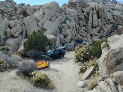
Mojave Desert / Mohave Camping Mojave, one of the largest deserts in the USA. Named after the Mohave tribe of Native Americans, it contains a number of ghost towns, the old railroad depots, and nearly 2000 plants species. The Mojave Desert is crossed by major routes - Interstate 15, Interstate 40, US Highway 395 & US Highway 95. READ MORE Right in the middle of the Mojave Desert is the National Preserve. The largest joshua tree forest in the state of Cali. Summer temps can easily reach the triple digits, so camping and hiking is most favored in autumn, winter or spring months. There are many primitive style (free) camp spots inside the park and surrounding the park, and there are also a few developed campgrounds as well. Goffs schoolhouse to the east has outdoor showers. Hole in the Wall Campground Mid Hills Campground Black Canyon Corral & Group Camp Hundreds if not thousands of dirt roads network the Mojave desert This desert park is an ideal spot for "i

Kennedy Meadows California

Image
General Store at Kennedy Meadows, on the Kern Plateau, California There are 2 different places in the Sierra Nevada mountains called Kennedy Meadows. This one photographed above is on the Kern Plateau, located in the Southern Sierra in between Dome Land Wilderness & Golden Trout Wilderness . The infamous Pacific Crest Trail (the PCT) passes through this region. Sequoia National Forest spans most of the land to the south and west of Kennedy Meadows. Inyo National Forest sits directly to the east. Monache Meadow s and Olancha Peak are to the north side kennedy meadows on the kern plateau -  High elevation Sherman's Pass Road leads uphill from the west, where the steep turn off, next to the Kern River is often gated. Way north of Kernville, CA . Shermans Pass Rd is a paved back road that closes annually for snow, so call the local ranger for up to date weather & road conditions. Access to Kennedy Meadows from the east side, Inyo County Road # J41 off of Easte

Sierra Nevada Map

Image
The Sierra Nevada mountains range in elevation from 2000' - 14,494' above sea level. From rolling foothills with creek, oaks & wildflowers to tower granite peaks, alpine lakes & high country meadows of the Eastern Sierra. Imus Geographics makes a nice overview map of the Sierra Nevada mountains and this one is a hot seller on Total Escape! Over at the Total Escape map store we have an epic selection of Sierra Maps - see all Sierra Nevada Maps Eastern Sierra Map Gold Country Maps Lassen Maps Mammoth Maps Mt Whitney Maps Sequoia Maps Tahoe Maps Yosemite Maps Northern Sierra Forest Map Set Central Sierra Forest Map Set Easterm Sierra Forest Map Set Southern Sierra Forest Map Set California Sierra Wilderness Maps PCT - Pacific Crest Trail Maps  

Camping in California

Image
California is the most epic place to live for those who love the outdoors and camp often. Terrain can be extreme like the vast deserts and higher elevation mountains. Moderate elevation forest, mountains and rural regions, such as river canyons in the gold country and Northern California. Mild and mellow landscape w/ developed campgrounds along the coast and near the urban centers. The weather is always decent somewhere in the golden state. Deserts are prime areas for wintertime camping, off-roading, old mines and ghost towns, as well as early Spring wildflowers. Wine country camping , farm-stays and recreation reservoirs are abundant all around the Central Valley and areas north of San Francisco. Coastal and beach camping is the most popular and sought-after destinations, so make your reservations if you want a guarantee spot. City camping is primarily offered by State Parks, county parks, regional parks and private RV resorts. California mountains are the place to be in the

South Fork Kern River

Image
The Kern River is the biggest waterway in the southern Sierra Nevada mountains. Its headwaters start near Mount Whitney and eventually make their way down the granite gorge of the Lower Kern into the citrus groves near Bakersfield, CA. The Upper Kern is the stretch of river above Lake Isabella, north of Kernville, along the paved highway leading to the Forks of the Kern . The smaller South Fork Kern River leads into Lake Isabella from the eastern desert ranges, towering high above the north Mojave. This southern Sierra side-kick river descends down from high elevations on the Eastern Sierra, traverses through forests, meadows, granite, waterfalls and turns sharp 45 degrees to the west near at Hwy 178 @ Canebrake (jct. Chimney Peak Backcountry Byway). Kennedy Meadows, Troy Meadows, and Monache Meadows are all atop the area known as the Kern Plateau. Bakeoven Meadow is a slice of wilderness  heaven surrealism, surrounded by peaks and forest, all this beauty on the Inyo and Sequoia